
Drone Photography for Las Vegas Real Estate: What Every Agent Should Know
Drone photography Las Vegas real estate agents rely on is no longer a luxury reserved for multimillion dollar listings. Drone photography for Las Vegas real estate is no longer a luxury reserved for multimillion dollar listings it’s quickly becoming a standard part of how competitive agents market every property. Las Vegas drone photography delivers a level of visual storytelling that helps buyers connect with a property before they ever walk through the door. If you haven’t added aerial photography to your listing toolkit yet, here’s everything you need to know.
What Is Real Estate Drone Photography?
Real estate drone photography uses FAA-licensed pilots and professional drone equipment to capture stunning aerial images and video of a property and its surroundings. From above, a drone can reveal things a ground-level camera simply cannot the size of the lot, the layout of the neighborhood, proximity to amenities, mountain views, golf courses, community pools, and more.
At Cactus Sky Media, all drone photography is performed by an FAA Part 107 certified pilot, meaning every aerial shoot is fully licensed, insured, and compliant with federal regulations. This matters not all photographers offering drone services are properly certified, which can expose agents and sellers to liability.
Why Las Vegas Properties Benefit From Drone Photography
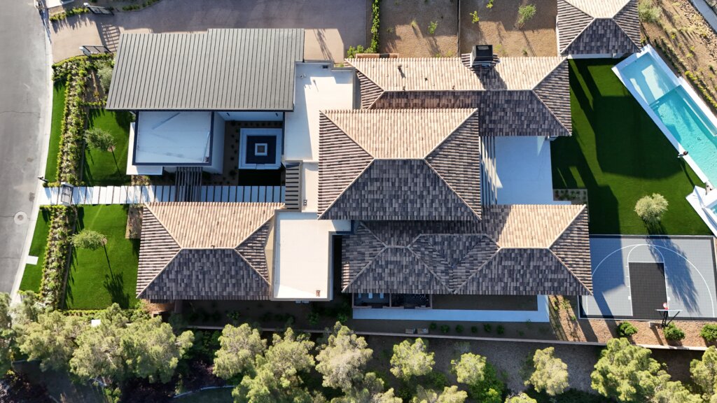
Las Vegas is a unique real estate market. Many properties here have features that are best appreciated from above:
- Mountain and desert views — Red Rock Canyon, the Spring Mountains, and the Las Vegas Strip skyline are breathtaking from an aerial perspective
- Large lots and custom homes — Aerial shots show the full scope of a property in ways ground photography cannot
- Community amenities — Golf courses, pools, parks, and gated entry points photograph beautifully from above
- Location context — Show buyers exactly where the home sits relative to schools, shopping, and major roads
- Luxury communities — Summerlin, Ascaya, Lake Las Vegas, and Henderson’s guard-gated communities all benefit from the premium feel aerial photography delivers
What Las Vegas Agents Say About Drone Photography
Agents who regularly include drone photography in their listing packages report that listings feel more premium, generate more online engagement, and attract more serious buyers. In a market where buyers are often relocating from out of state and making decisions based entirely on online photos, aerial imagery gives them the full picture, literally.
What to Expect From a Drone Photography Session in Las Vegas
Drone sessions are typically scheduled in the morning or late afternoon when light conditions are ideal and wind speeds are lower. A standard aerial shoot takes approximately 30 to 45 minutes and includes both still photos and optional video footage.
Final edited aerial images are delivered alongside your standard interior and exterior photos so everything arrives together and your listing can go live on schedule.
How to Add Drone Photography to Your Next Listing
Adding drone photography to your next Las Vegas listing is simple. When you book your session with Cactus Sky Media just let us know you’d like to include aerial coverage and we’ll handle everything from there flight planning, airspace authorization, shooting, and editing.
Drone photography is available as a standalone service or as part of a complete listing photography package including interiors, exteriors, twilight shots, and 2D floorplans. Whether you are listing a starter home in the southwest valley or a luxury estate in Summerlin, drone photography Las Vegas real estate agents trust delivers a competitive edge that standard ground photography simply cannot match.
Ready to take your Las Vegas listings to new heights? Contact Cactus Sky Media today to book your drone photography session. Serving agents throughout Las Vegas, Summerlin, Henderson, Lake Las Vegas, Ascaya, and the surrounding areas.